3.1.1.2 Tectonic hazards
A bit of a retro introduction to plate tectonics, volcanoes and earthquakes
|
Key Idea
Earthquakes and volcanic eruptions are the result of physical processes. Plate tectonics theory. Plate tectonics is a scientific theory that describes the large scale motion of the movement of a number of large and small places that make up the earths lithosphere (crust and upper mantle). These plates are believed to have been moved over the last hundred of millions of years. The theory of plate tectonics builds on the concept of continental drift which developed in the first few decades of the 20th century. The Earth's lithosphere is composed of seven or eight major plates (depending on how they are defined) and many minor plates. Where the plates meet, their motion determines the type of boundary: constructive, destructive or conservative. Watch video 1 on plate tectonic theory for more information. In order to truely understand plate tectonics theory you need to have an understanding of the layers of the earth and convection currents. To check you understanding of these take a look at the following links Layers of the Earth Convection Currents Global distribution of earthquakes and volcanic eruptions and their relationship to plate margins. Take a look at image 1 - map of tectonic plates. Then visit this website showing recent earthquakes. What patterns do you notice? The lithosphere is broken up into tectonic plates. Where the plates meet, their motion determines the type of plate boundary: constructive, destructive or conservative. Earthquakes, volcanic activity, mountain-building, and ocean trenches occur along these plate boundaries. Tectonic plates are able to move due to convection currents within the mantle (see image 2). The tectonic plates float on top of the mantle and move as the liquid rock in the mantle gets heated from the core. The warm material has more energy and so it rises towards the surface. Eventually when it cools down the material will start to sink as it has less energy than the warmer material around it. This up-down motion is called a convection current. The location of volcanoes, fold mountains, rift valleys and ocean trenches are influenced by the relative motion of the tectonic plates. Whilst earthquakes can occur along all 3 plate boundaries the others are more particular. Physical processes taking place at different types of plate margin (constructive, destructive and conservative) that lead to earthquakes and volcanic activity. The movement of the plates typically ranges from zero to 100 mm annually, it is this movement of tectonic plates that leads to areas of crust formation and destruction. As a result there are three key plate margins you need to understand; constructive, destructive and conservative. 1. Destructive Plate Boundaries As the name suggests at destructive plate boundaries the tectonic plate is destroyed as the oceanic crust is denser (heavier) than continental crust so is forced beneath it as they are pushed together (see image 3). This process of one plate being forced under another is called subduction. The point where subduction occurs is called the subduction zone. At the subduction zone a deep sea trench is formed where the plate is being forced downwards under the continental plate. The heat from the mantle causes the oceanic crust to melt and due to the convection currents this molten rock floats back to towards the surface because it is lighter than the mantle. Eventually this molten rock will erupt back to the surface as magma causing volcanoes to form. 2. Constructive Plate Boundaries As the name suggests at constructive plate boundary land is created. When tectonic plates pull apart magma from the mantle rises, it reaches the surface where it then cools and solidifies to fill the space. If oceanic crust is pulling apart from oceanic crust then new crust is created, this therefore means that in some places the sea floor is spreading (see image 4). This is what is happening along the Mid-Atlantic Ridge. As a result small chains of islands are created in some places as the new crust breaks the surface of the water. This is how Iceland was created since it lies on the constructive boundary between the Eurasian plate and the North American plate. If continental crust is pulling apart from continental crust then the same process occurs however this time a rift valley is formed such as that found in East Africa as part of the Great Rift Valley (see image 6). 3. Conservative Plate Boundaries These plate boundaries are different to the former two, in that no magma is created and therefore no volcanoes exist. Conservative plate boundaries move along side each other, either in opposite directions or in the same direction but at different speeds (see image 7). Since tectonic plates are made of rock that can be brittle and jagged is can be difficult for plates to slide past one another. Sometimes the plates get stuck and pressure builds until eventually the friction is overcome and the plates slip past in a sudden movement creating an earthquake. Probably the most famous conservative plate boundary is the San Andreas Fault on the western coast of North America. 4. Collision Plate Boundaries Final one to be aware of is the collision plate boundary whereby two continental plates meet. Since continental plates are the same density, neither can subduct therefore the plates are forced together (see image 8). Due to the great pressure that develops the rocks crumble, merge and fold to form mountain chains like the Himalayas. These are called fold mountains. The Himalayas are still growing as a result of the Eurasian and Indian plates continuing movements at a rate of approximately 1-2 cm a year. Video 2 - Types of Plate Boundaries
Task - Complete the plate boundary Venn diagram task sheet.
Optional Task - Download the instructions for Playdough Plate Boundaries.
|
Video 1 - Plate Tectonic TheoryImage 1 - Map of Tectonic Plates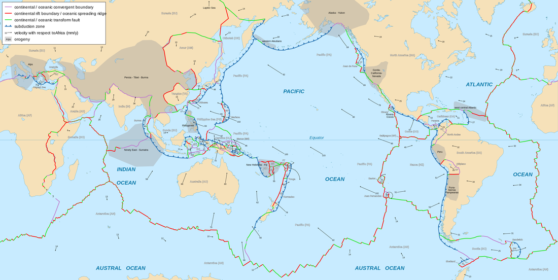
Source: https://en.wikibooks.org/wiki/File:Tectonic_plates_boundaries_detailed-en.svg
Image 2 - Convection Currents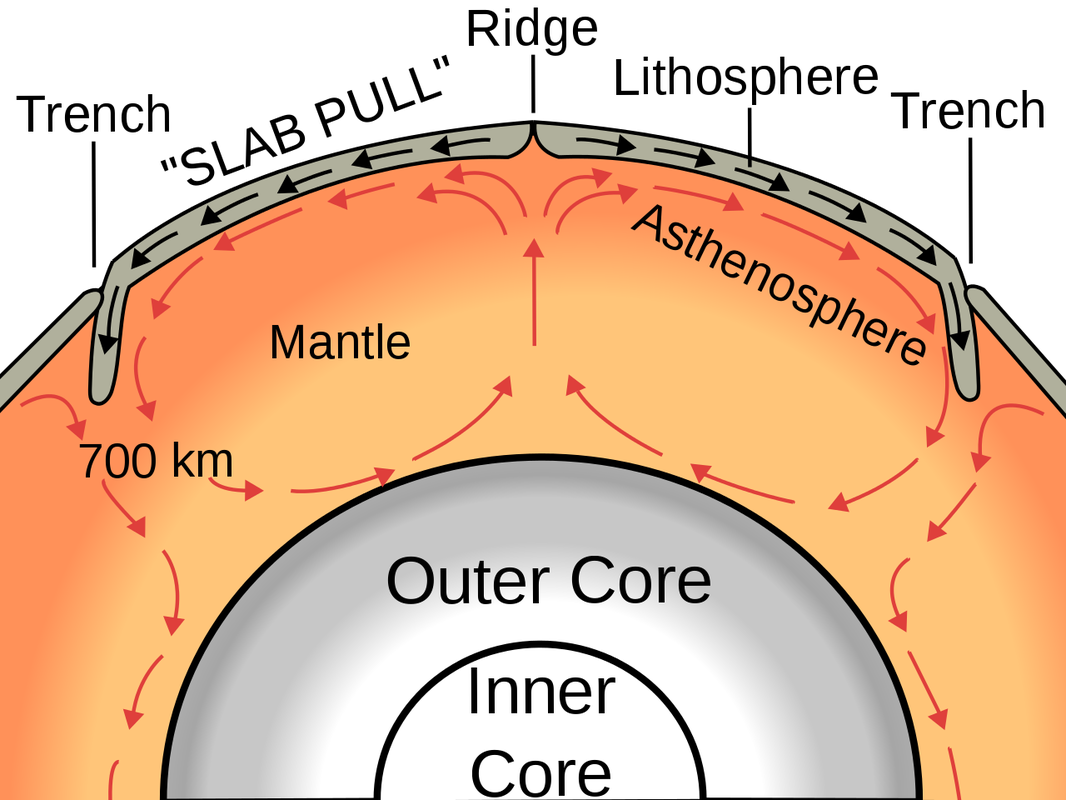
Source - https://commons.wikimedia.org/wiki/File:Oceanic_spreading.svg
Image 3 - Destructive Plate Boundary
Source - https://commons.wikimedia.org/wiki/File:Destructive_plate_margin.svg
Image 4 - Constructive Plate Boundary & Sea Floor Spreading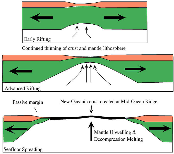
Source - https://commons.wikimedia.org/wiki/File:Rifting_to_Spreading_Transition.jpg
Image 5 - Mid-Atlantic Ridge in Iceland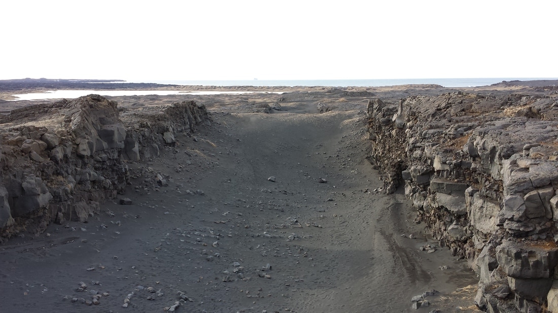
Source - Miss Hewett's Archive
Image 6 - Constructive Plate Boundary & Rift Valley Formation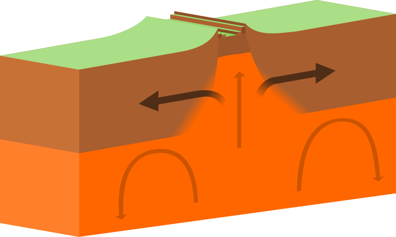
Source - https://commons.wikimedia.org/wiki/File:Continental-continental_constructive_plate_boundary.svg
Image 7 - Conservative Plate Boundary
Source - https://en.wikipedia.org/wiki/Transform_fault
| ||||
Something extra - Fold Mountain Formation
|
|
|
Key Idea
The effects of, and responses to, a tectonic hazard vary between areas of contrasting levels of wealth.
|
Earthquakes
Primary and secondary effects of a tectonic hazard. Primary effects are a direct result of the hazard e.g. buildings collapsing, deaths, or gas pipes rupturing as result of an earthquake Secondary effects occur as a result of the primary effects e.g. deaths as a result of the buildings collapsing days later or fires as a result of gas pipes rupturing Video 3 - Effects of EarthqaukesImmediate and long-term responses to a tectonic hazard.
Immediate responses is the action taken immediately or shortly after a tectonic hazard has occurred e.g. Friends and neighbours search through the rubble of collapsed buildings for survivors. Long-term responses are the actions taken weeks, months and years after the disaster e.g. rebuilding of homes, schools and hospitals after they collapsed. Use named examples to show how the effects and responses to a tectonic hazard vary between two areas of contrasting levels of wealth. LIC - Haiti 2010 HIC - Canterbury Christchurch, New Zealand 2011 Collect the following information sheets
|
Volcanic Eruptions
Primary and secondary effects of a tectonic hazard. Primary effects are a direct result of the hazard e.g. hot ash and dust released causing suffocation of people and livestock Secondary effects occur as a result of the primary effects e.g. hot ash and dust covered and destroyed crops meaning a loss of income Video 4 - Effects of Volcanic EruptionsImmediate and long-term responses to a tectonic hazard.
Immediate responses is the action taken immediately or shortly after a tectonic hazard has occurred e.g. evacuating people away from the direction of the ash cloud Long-term responses are the actions taken weeks, months and years after the disaster e.g. rebuilding properties that collapsed under the weight the ash and dust Use named examples to show how the effects and responses to a tectonic hazard vary between two areas of contrasting levels of wealth. TO BE ADDED WHEN STUDIED LIC - Democratic Republic of Congo, 2002 HIC - Iceland 2010 Collect the following information sheets
| ||||||||
Case Studies
Task - Select either the response to volcanic eruptions or earthquakes. Create two case study sheets on the two named examples provided at contrasting levels of wealth - one sheet for each named example. You may wish to use or amend one of the general case study template sheets.
Task - Select either the response to volcanic eruptions or earthquakes. Create two case study sheets on the two named examples provided at contrasting levels of wealth - one sheet for each named example. You may wish to use or amend one of the general case study template sheets.
Homework PPQ1.
|
| ||||||
Exam Style Question
Using named examples, explain why the effects of a tectonic hazard vary between areas of contrasting levels of wealth. [6 marks]
Using named examples, explain why the effects of a tectonic hazard vary between areas of contrasting levels of wealth. [6 marks]
|
|

|
Key Idea
Management can reduce the effects of a tectonic hazard.
Video 5 - Why do people live in tectonically active areas? A high income example - Iceland |
Video 6 - Why do people live in tectonically active area? A (low) middle income example - Guatamala |
|
Earthquakes
Reasons why people continue to live in areas at risk from a tectonic hazard. There are many places where people live in tectonically active locations that are susceptible to earthquakes. People choose or continue to live in these areas for a variety of reasons which may include:
|
Volcanoes
Reasons why people continue to live in areas at risk from a tectonic hazard. There are many places where people live in tectonically active locations where there is risk of volcanic eruptions. People choose or continue to live in these areas for a variety of reasons which may include:
|
How monitoring, prediction, protection and planning can reduce the risks from a tectonic hazard.
Changes to a volcano's ground surface (volcano deformation) appear as swelling, sinking, or cracking, which can be caused by magma, gas, or other fluids such as water moving underground or by movements in the earth's crust due to motion along faults. Often, this deformation is very small—a few centimeters or less—and so can only be detected and monitored with very sensitive instruments.
Ways of monitoring and predicting tectonic activity include:
Ways of protecting and planning for tectonic activity include:
Changes to a volcano's ground surface (volcano deformation) appear as swelling, sinking, or cracking, which can be caused by magma, gas, or other fluids such as water moving underground or by movements in the earth's crust due to motion along faults. Often, this deformation is very small—a few centimeters or less—and so can only be detected and monitored with very sensitive instruments.
Ways of monitoring and predicting tectonic activity include:
- Thermometers or infrared cameras to identify movement of magma towards the surface
- Identifying ground deformation (bulges in the ground) helps us to identify that there is movement of magma, GPS or Tilt-meters are used to measure this.
- Changing gas levels suggest there is something happening beneath the ground.
- Hydrothermal activity (changes in water temperature) give us clues of what is happening under the surface.
- Seismologists measure any shaking of the ground, this can indicate magma movement.
Ways of protecting and planning for tectonic activity include:
- Education in what to do in the event of an earthquake or volcanic eruption through TV, internet, posters and leaflets.
- Government emergency action plans for key services.
- Practice drills to ensure emergency action plans are sufficient.
- Provision of specialist training for emergency service personnel that would provide first aid in temporary/field hospitals.
- Families can put together emergency kits with basic essentials to help them in the event of a disaster.
- Disaster survival kits can be created and stored to provide survivors with basic essentials after a disaster.
- Buildings can be made earthquake proof through methods such as cross bracing, counter weights and base isolation.
Video 7 - Can we predict earthquakes? |
Video 8 - How to predict volcanic eruptions |
