3.1.1.3 Weather hazards
 Source -https://commons.wikimedia.org/wiki/File:Atmospheric_circulation.svg
Key Idea
Global atmospheric circulation helps to determine patterns of weather and climate.
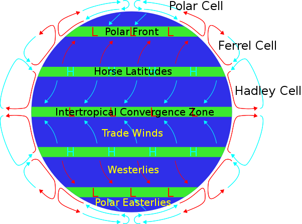
General atmospheric circulation model: pressure belts and surface winds.
The circulation of the air in the atmosphere has a great effect on the our climate and the weather we experience on a day-to-day basis. As air is heated it expands and rises, leaving low pressure. In areas where the air is cool, the air is denser and so it falls to the surface of the Earth, creating areas of high pressure.
The pressure belts and sruface winds are influenced by three main cells which occur in both the northern and southern hemispheres - the Hadley cell, the Ferrel cell and the Polar cell - and make up the Tri-Celluar Atompshioeric Ciriculation Model.
The vast bulk of the atmospheric motion occurs in the Hadley cell. The high pressure systems acting on the Earth's surface are balanced by the low pressure systems elsewhere. As a result, there is a balance of forces acting on the Earth's surface.
The Tri-celluar Model
The Hadley Cell - To start with warm air rises at the equator and travels to around 30º North where it cools and sinks to the surface, before returning to the tropics.
At the equator there is an area of low pressure, due to the rising and expanding air. At around 30º North the sinking air creates an area of high pressure.
The Ferrel Cell - This cell is powered by the other two cells and is found between 60º North and 30º North.
The Polar Cell - Here cold air sinks at the North Pole, before flowing south at the surface. Here it is warmed by contact with land/ocean around 60º North, where it rises.
For how the tri-celluar model influences climate and biomes click here
Global atmospheric circulation helps to determine patterns of weather and climate.
General atmospheric circulation model: pressure belts and surface winds.
The circulation of the air in the atmosphere has a great effect on the our climate and the weather we experience on a day-to-day basis. As air is heated it expands and rises, leaving low pressure. In areas where the air is cool, the air is denser and so it falls to the surface of the Earth, creating areas of high pressure.
The pressure belts and sruface winds are influenced by three main cells which occur in both the northern and southern hemispheres - the Hadley cell, the Ferrel cell and the Polar cell - and make up the Tri-Celluar Atompshioeric Ciriculation Model.
The vast bulk of the atmospheric motion occurs in the Hadley cell. The high pressure systems acting on the Earth's surface are balanced by the low pressure systems elsewhere. As a result, there is a balance of forces acting on the Earth's surface.
The Tri-celluar Model
The Hadley Cell - To start with warm air rises at the equator and travels to around 30º North where it cools and sinks to the surface, before returning to the tropics.
At the equator there is an area of low pressure, due to the rising and expanding air. At around 30º North the sinking air creates an area of high pressure.
The Ferrel Cell - This cell is powered by the other two cells and is found between 60º North and 30º North.
The Polar Cell - Here cold air sinks at the North Pole, before flowing south at the surface. Here it is warmed by contact with land/ocean around 60º North, where it rises.
For how the tri-celluar model influences climate and biomes click here

|
Task - Watch video 1 on atmospheric circulation and complete the worksheet below.
| ||
Video 1 - Atmospheric Circulation |
Video 2 - The Coriolis Effect |
|
Key Idea
Tropical storms (hurricanes, cyclones, typhoons) develop as a result of particular physical conditions. Global distribution of tropical storms (hurricanes, cyclones, typhoons) A tropical storm (also known as a hurricane, cyclones, typhoon dependent where you are in the world) is a rotating, organized system of clouds and thunderstorms that originates over tropical or subtropical waters and has a closed low-level circulation. Tropical cyclones rotate counterclockwise in the Northern Hemisphere. They are classified as follows:
[Accessed 11/04/2017] |
Video 3 - what are hurricanes, typhoons and tropical cyclones? |

|
Task - Look carefully at image 1 and 2 below. Do you notice any patterns in the general course of tropical cyclones and the tropical cyclones that occurred between 1945-2006?
Describe the pattern in images 1 and 2 ensuring you refer to oceans and continents. |
|
Image 1 shows global tropical cyclone tracks. The dashed line indicates that the formation of significant storms in that area is very rare.
Image 1 - Global Cyclone Tracks
Source - https://commons.wikimedia.org/wiki/File:Tropical_Cyclone_Average_Track_worldwide.svg
|
Image 2 shows the tracks of tropical cyclones between 1945 and 2006.
Image 2 - Tropical Cycles 1945-2006
Source -
https://commons.wikimedia.org/wiki/File:Tropical_cyclones_1945_2006_wikicolor.png
|

|
Task - download the worksheet and complete the tasks set.
|
| ||
|
An understanding of the relationship between tropical storms and general atmospheric circulation.
1.Tropical cyclones originate in warm ocean waters close to the equator because this area receives the greatest concentration of energy from the sun, this energy warms the oceans to 27°c that’s needed for tropical cyclones to form. They form at least 5° North or south of the equator because the Coriolis Effect is great enough to cause the storm to spin 2. They develop at an area of low pressure, which means the air is rising, cooling and condensing to from clouds. As more and more air rises and condenses the clouds get thicker and lower in the atmosphere, eventually a storm will begin to develop. 3. Air blows into the low pressure systems from the Tropic of Cancer and Tropic of Capricorn which are 30° north and south of the equator, where the high pressure belts lie, whilst the air moving from high to low pressure generates winds called the trade winds, these converge and meet which causes the storm to spin. |
Video 4 - Forecasting Tropical Cyclones |
Causes of tropical storms and the sequence of their formation and development. The structure and features of a tropical storm.
Tropical storms form as a result of some very important ingredients (see image 3). Firstly to form they need warm ocean water where the top 50 meters are at least 26 degrees Celsius. Secondly they need wind. In the case of hurricanes that form in the Atlantic Ocean, the wind blowing westward across the Atlantic from Africa provides the necessary ingredient. As the wind passes over the ocean's surface, water evaporates and rises. As it rises, the water vapour cools, and condenses back into large water droplets, forming large cumulonimbus clouds. These clouds are just the beginning, they develop a very clear structure and weather pattern, as shown in images 4 and 5 which show a cross section and the conditions associated with the passage of a tropical storm.
Tropical storms form as a result of some very important ingredients (see image 3). Firstly to form they need warm ocean water where the top 50 meters are at least 26 degrees Celsius. Secondly they need wind. In the case of hurricanes that form in the Atlantic Ocean, the wind blowing westward across the Atlantic from Africa provides the necessary ingredient. As the wind passes over the ocean's surface, water evaporates and rises. As it rises, the water vapour cools, and condenses back into large water droplets, forming large cumulonimbus clouds. These clouds are just the beginning, they develop a very clear structure and weather pattern, as shown in images 4 and 5 which show a cross section and the conditions associated with the passage of a tropical storm.
Image 3 - Ingredients for a Hurricane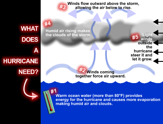
Image 4 - Cross Section of Hurricane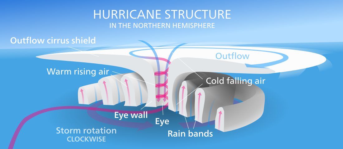
Source - By Kelvinsong - Own work, CC BY 3.0, https://commons.wikimedia.org/w/index.php?curid=23226142
Image 5 - Passage of a Hurricane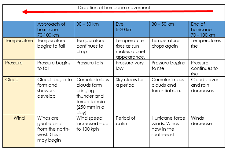
|
Video 5 - Tropical Storm FormationVideo 6 - Flying through a hurricane eye wall
Task - Complete the Critical Thinking task about the passage of a hurricane in the worksheet below.
| ||||||

|
How climate change might affect the distribution, frequency and intensity of tropical storms
Evidence points towards a rising average of global sea temperature. In fact the global sea surface temperature is approximately 1 degree Celsius higher now than it was 140 years ago. That may not seem like a lot but it has a huge impact on the fragile planet we live on. "Over the past 25 years the rate of increase in sea surface temperature in all European seas has been about 10 times faster than the average rate of increase during the past century. In five European seas the warming occurs even more rapidly. In the North and Baltic Seas temperature rose five to six times faster than the global average over the past 25 years, and three times faster in the Black and Mediterranean Seas." The European Environment Agency (EEA) [Accessed 11/04/2017] Make a prediction - what do you think will happen to the distribution, frequency and intensity of tropical storms? Distribution Cold ocean temperatures keep waters below the temperature needed ( 27°C) for tropical storms to develop however as ocean temperatures are warming tropical storms may begin effecting areas further north and south of the equator, areas that were once too cold for tropical storms to form. Frequency Although Atlantic tropical storms lasting more than 2 days have not increased in number storms lasting less than two days have increased sharply (see image 7). This could be because more are occurring or that observing and monitoring has improved thanks to aircraft, radar and satellites. Intensity The intensity of storms is seen to be increasing and linked to higher sea temperatures, increased evaporation and atmospheric warming increasing convection leading to lower surface pressure and therefore stronger winds. However some disagree and suggest that more data is needed over a longer time period to say for sure that storm intensity is increasing. Power Dissipation Index (PDI) - the sum of the maximum one-minute sustained wind speed cubed, at six-hourly intervals, for all periods when the cyclone is at least tropical storm strength Image 7 - Number of moderate and short duration storms in the Atlantic since 1880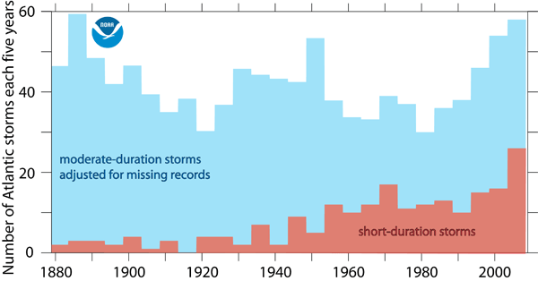
Source -https://www.gfdl.noaa.gov/historical-atlantic-hurricane-and-tropical-storm-records/ and adapted from Landsea, Vecchi, Bengtsson and Knutson (2009, J. Climate)
|
Image 6 - Average Global Sea Temperature Change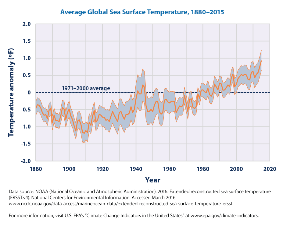
Source - United States Environmental Protection Agency https://www.epa.gov/climate-indicators/climate-change-indicators-sea-surface-temperature
Video 7 - Hurricanes and Climate ChangeImage 8 - PDI vs. Sea Surface Temperature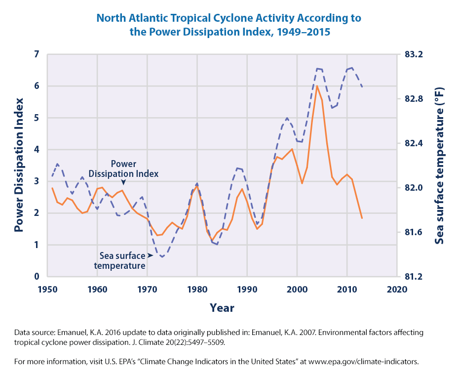
Source - https://www.epa.gov/climate-indicators/climate-change-indicators-tropical-cyclone-activity. Data from Emanuel, K.A. 2016 update to data originally published in: Emanuel, K.A. 2007. Environmental factors affecting tropical cyclone power dissipation. J. Climate 20(22):5497–5509.
|

|
Task - How is climate change likely to affect the distribution, frequency and intensity of tropical storms?
|
Key Idea
Tropical storms have significant effects on people and the environment.
Primary and secondary effects of tropical storms.
Primary effects are a direct result of the hazard e.g. high winds, torrential rain and storm surges,and flooding
Secondary effects occur as a result of the primary effects e.g. people are displaced from their flooded homes
Immediate and long-term responses to tropical storms.
Immediate responses is the action taken immediately or shortly after a tectonic hazard has occurred e.g. evacuation of those affected, delivery of aid to areas affected
Long-term responses are the actions taken weeks, months and years after the disaster e.g. debris removal and rebuilding of damaged structures, reinforcing of coastal flood defences
Use a named example of a tropical storm to show its effects and responses. How monitoring, prediction, protection and planning can reduce the effects of tropical storms.
|
Developed Country
High Income Country Hurricane Katrina, USA (2005) To be added when studied |
Developing Country
Low Middle Income Country Typhoon Haiyan, Philippines (2013) To be added when studied |
Video 8 - What is severe/extreme weather?
|
Key Idea
The UK is affected by a number of weather hazards. An overview of types of weather hazard experienced in the UK. In the UK our weather is influenced by a variety of factors including air masses, weather fronts and the global atmospheric system. Watch video 9 to find out more about the role of air masses and weather fronts. As a result of all the combining factors as well as the influence of climate change in the UK we can experience several different weather hazards within the same year. Some previous weather hazards have included: November 2016 - Strong wind and heavy rain from Storm Angus December 2015 - Flooding in Cumbria from Storm Desmond January - February 2014 - Winter Storms March 2013 - Low temperatures and Snow July 2007 - Heavy rainfall and flooding July 2006 - Record breaking heat and sunshine January 2003 - Record breaking temperatures These events can lead to drought and flooding. |
Video 9 - Air Masses and Weather FrontsVideo 10 - Britain's Worst Weather Playlist |
Key Idea
Extreme weather events in the UK have impacts on human activity.
An example of a recent extreme weather event in the UK to illustrate:
• causes • social, economic and environmental impacts
• how management strategies can reduce risk.
To be added when studied
Extreme weather events in the UK have impacts on human activity.
An example of a recent extreme weather event in the UK to illustrate:
• causes • social, economic and environmental impacts
• how management strategies can reduce risk.
To be added when studied
Video 11 - Globally is weather becoming more extreme?
Homework Project
Evidence that weather is becoming more extreme in the UK.
Task - using the internet, the textbook and the other resources provided in class to find evidence to support that weather in the UK is becoming more extreme. Use the evidence you find to create a 10 slide powerpoint to explain how the weather is becoming more extreme in the UK. These websites and news stories might be of assistance: Extreme weather and climate change: is there a link? Extreme weather already on increase due to climate change, study finds Is Britain experiencing extreme weather? Yes. Extremely mild... UK weather: Why the recent devastating floods will become the new normal Study: Global warming 'doubles risk' of extreme weather From the UK Government Climate change explained From the Met Office How is climate linked to extreme weather? UK climate - Extremes Climate: observations, projections and impacts |
Video 12 - UK Climate Change RiskVideo 13 - Climate Change and Extreme Weather |
